 |
| The distance from Brookport, Illinois to Muscle Shoals, Alabama is 170 miles. |
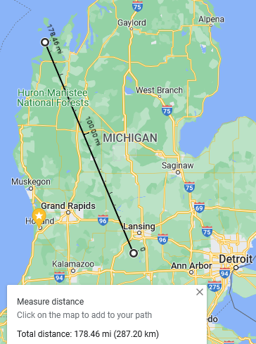 |
| As the crow-flies, the distance from Eaton Rapids, Michigan to Glen Arbor is 178 miles. |
 |
| The distance from South Miami, Florida to the Georgia state-line is 360 miles. |
|
| The distance from Brookport, Illinois to Muscle Shoals, Alabama is 170 miles. |
|
| As the crow-flies, the distance from Eaton Rapids, Michigan to Glen Arbor is 178 miles. |
|
| The distance from South Miami, Florida to the Georgia state-line is 360 miles. |
And it is virtually the same distance from Atlanta to Miami as it is from Atlanta to NY. That tidbit too a while to wrap my arms around when young. In my mind FL was close and NY far. Roger
ReplyDeleteAnd Reno, Nevada is further west than Los Angeles.
ReplyDeleteI like the fact that the western tip of Virginia is west of Detroit
ReplyDeleteThis is what i love about your writing, ERJ. Occasionally, just downright puzzling.
ReplyDeleteWhat do Brockport, Mussel Shoals, Eaton Rapids, Glen Arbor, Miami and Florida-Georgia Line have in common?
!/4 of Mexico is North of Brownsville , Tx
ReplyDeleteBegin now earning every month an extra amount of $17k or more just by doing very simple and easy online job from home. I have received $18953 in my last month direct in my bank acc by doing this easy home base job just in my part time for 2 hrs maximum a day online. Even a child can now do this job and earns money online. Everybody can get this home job right now and start earning dollars online by follow details here………. Www.jobsrevenue.com
ReplyDeleteAviators (the crows, too) have known such things since road maps first came out.
ReplyDeleteMy fascination and enjoyment of paper maps and charts is very high.
At any given time I have several maps, or aeronatical or mariner chart, or atlas (both, current and expired) within easy reach. I regularly pull out the samevto make note of some odd twist in geography.
Just today I looked to see which towns and terrain across the U.S. stood at N33*00'.
The state of AK is the furthest north, west, and east.
ReplyDeleteThe distance between Beaumont Texas and El Paso Texas is greater than the distance between El Paso Texas and Los Angeles California.
ReplyDeleteWestern Virginia is further west than West Virginia.
The reason AK is the furthest Eastern state, is because the far end of the Aleutian Islands is on the other side of longitude 180 and is therefore in the eastern hemisphere.
Most of the population of Canada lives south of the northern tier of the US.
The cities of Paris, France and London, UK are both further north than the twin cities of Minneapolis and St. Paul Minnesota.
Forgot one...
ReplyDeleteIf the political borders of California were superimposed onto the east coast, it would extend all the way from NYC to north Florida.