 |
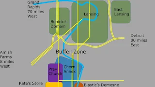
| Overview. Twelve miles from north-south and twice that east-west. |
 |
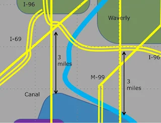
| Close-up of the Buffer Zone. Observation posts at the Waverly Road bridge, M-99 bridge and on Canal Road where it enters Chernovsky's Annex. |
 |
| Scale. |
 |
| Likely staging areas for opposing forces' mechanized assault. |
 |
| Columbia Road bridge where Spackle was previously assigned. Columbia Road is the east-west road on the bottom of the overview map. You can double-click on the photos to embiggen them. |
 |
| Waverly Road bridge. Two lanes, narrow shoulders, post-and-rollformed guard-rail. |
 |
| M-99 bridge. Two full lanes each direction. Full shoulder on one side, half shoulder on the other. Jersey Barrier guard-rails. |
 |
| Potential staging area one with significant depth fore-shortening due to telephoto lens. Camera is looking northeast. |
 |
| Potential staging area one looking southwest. |
 |
| Potential staging area two looking northeast. |

Based on the distance scale indicated on the map, the first patrol that Quinn and his boys are on is about 12-14 miles. That is quite a long walk for their first time back out patrolling. Especially for a guy who is still not fully rehabbed from a gunshot wound to the buttocks. Definitely a young man's game.
ReplyDeleteI figured the east-west leg of Quinn's hike added another three miles.
DeleteYup, definitely a young man's game. At least the roving part of it is.
Fills in a lot of blanks! Thanks!!!
ReplyDeleteThanks. I do maps, and this helps.
ReplyDeleteI'd consider ripping up the approaches to the bridges. That blocks vehicular traffic but is easier to repair if and when necessary that it would be to rebuild blown bridges.