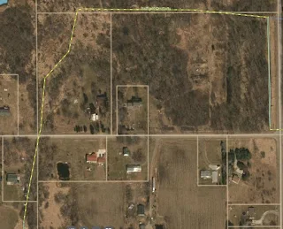
Last year, Columbia Highway was impassible for 37 days due to flooding.
The dashed portion of the drain, shown here, is underground. It is of an age where it is clay tile, butted end-to-end. The inside is rough and it is vulnerable to cracking and to tree roots intruding.
Another factor exacerbating the situation is that there is only 4' of drop over the half a mile of buried drain.
In the nominal condition (18" drain, roughness coefficient of 80, 6" rain and 4' of head) it would take 53 days to move all of the water that falls on the square mile drained by the upper reaches through that drain.
12" diameter tile was evaluated to simulate degraded performance due to sediment, roots and partially collapsed tile. 24" diameter was looked at as an upgrade.
Increased head, the height of the water in the swamp, was also evaluated.
In the nominal condition (18" drain, roughness coefficient of 150, 6" rain and 4' of head) it would take 28 days to move an all of the water through that drain.
Obviously, much of the water percolates through the soil as the estimated times shown on the charts are WAY longer than observed.
My take-away is that drains are very sensitive to increasing diameter (good) and smoother walls (good).
 |
| This image added in response to comment by B. |


The real issue will be cost of replacement and disruption of land, plus time/manpower vs. 'benefits'...
ReplyDeleteThe Drain Commission ran a hydro jet through the sections of buried drain they could get at. They say it is a temporary fix at best.
DeleteIt'd be cheaper and faster to raise the road by 6 inches, wouldn't it?
ReplyDeleteThe Eaton County Road Commissioner claims it is a drain problem.
DeleteHe also claims that it is IMPOSSIBLE to locally raise the road, that the only contract they "let" is for a full mile of road improvement.
The road bed would need to go up for a minimum of three feet for a distance of three hundred feet. I added an image of the elevation of the road centerline to the text of the post.
Wetlands are untouchable. :)
ReplyDeleteLooks like an opportunity for permaculturists to swoop in...By s-l-o-w-i-n-g- the water flow off the affected lands, and reducing the total volume attempting to go through the tile at flood time, the road could be made passable sooner.
ReplyDeleteBut who wants standing water on their crop fields? :)
and the prospect that *wetlands become untouchable*
p.s. My gut says there was *meant* to be standing water in that area.
Back before the 1920s all Eaton County it was a swamp until they put the drains in and drain it to make it farmland this is just one of those simple pictures of fixing the drain and drain the swamp
ReplyDelete